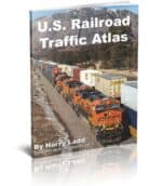
U.S. Railroad Traffic Atlas
SKU: ATLAS-RFD-USRTAOriginal price was: $29.95.$22.45Current price is: $22.45.
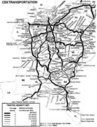
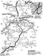
The only complete printed railroad traffic atlas available. In 92 detailed pages you get all rail lines, traffic density on each line, crew change points, helper districts, tonnage estimates between points and trackage rights over each line. Traffic density for the entire US rail system.
In stock
- Free Post Office shipping over $25!
- Free UPS shipping over $75!
The only complete railroad traffic atlas available. In 92 detailed pages you get all rail lines, traffic density on each line, crew change points, helper districts, tonnage estimates between points and trackage rights over each line. Traffic density for the entire US rail system! Just what a railfan needs to find the best lines!<br><br>This is a railroad atlas that is not anywhere duplicated today. Printed on premium glossy paper and bound so that it will hold up for years. Each state has a map, major systems have a map and there are specialized maps as well as notes about the making of the atlas, a listing of railroads and railroad abbreviations.
This is the latest edition, updated to 2003. Published by RailfanDepot via special arrangement with Ladd Publications.
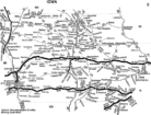
Close up maps include: Los Angeles, San Francisco, Chicago, Gary, Twin Cities, Duluth/Superior, St. Louis, Kansas City, New York, Buffalo, Philadelphia and Pittsburgh. Railroad system maps include Amtrak, BNSF, Canadian National (US lines), Canadian Pacific (US lines), C-S-X, DME-ICE, Guilford, Kansas City Southern, Norfolk Southern, and Union Pacific. Specialized maps include: BNSF Powder River coal tonnage, UP Coal Trains and Super Railroads (Very high density/tonnage).